Introduction
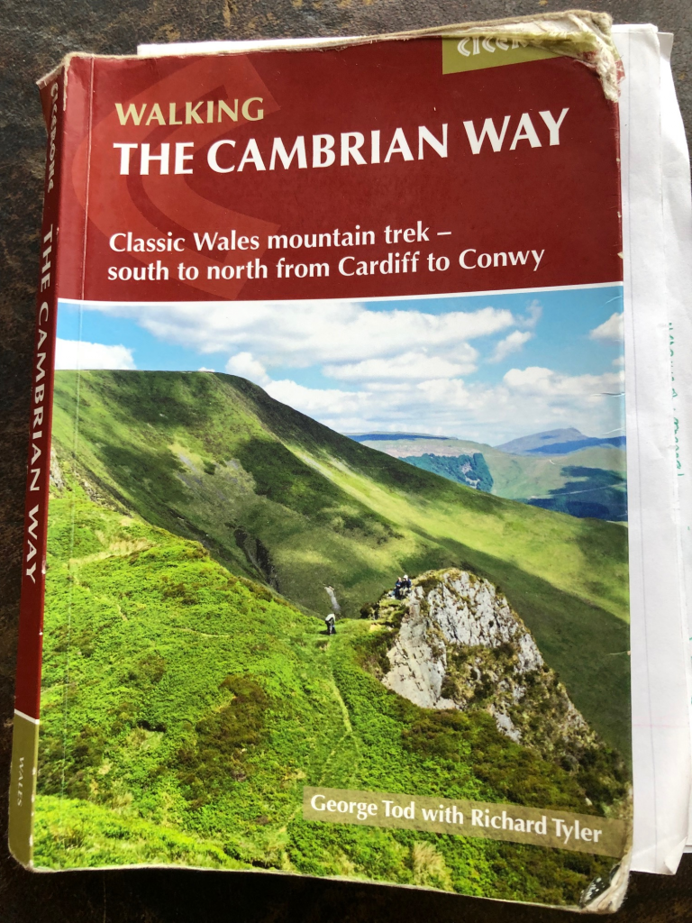
I walked the Cambrian Way in chilly Spring sunshine in 2022. Here follows my (rather verbose) account of the experience. Anyone wanting to undertake this walk really has to consult the official website: https://www.cambrianway.org.uk/ (opens in new tab). Whilst not essential, as I discuss below, the Cicerone Guide is pretty handy also.
The Walk
I prefer to say that I’ve “currently stopped working”. “Retired,” seems too final; and too old! However, despite my deafness, one sound I hear loud-and-clear is the ticking down of my biological clock. So the plan is to use the good years I have left to do the things I really enjoy, and long-distance walking is high on the list. After a spell of YHA volunteering ended in early March 2022, and with the days getting longer and warmer, there really was no excuse not to embark on some new adventure. I’d had my eye on the Cambrian Way for many years, even purchasing one of Tony Drake’s earlier guide-books long ago. But more recently I had been actively interrogating the Cambrian Way official web-site, and the route was penned in on the bucket list. With the long-range forecast predicting at least two weeks of sunshine, it seemed the stars were aligned and the time to go was now.
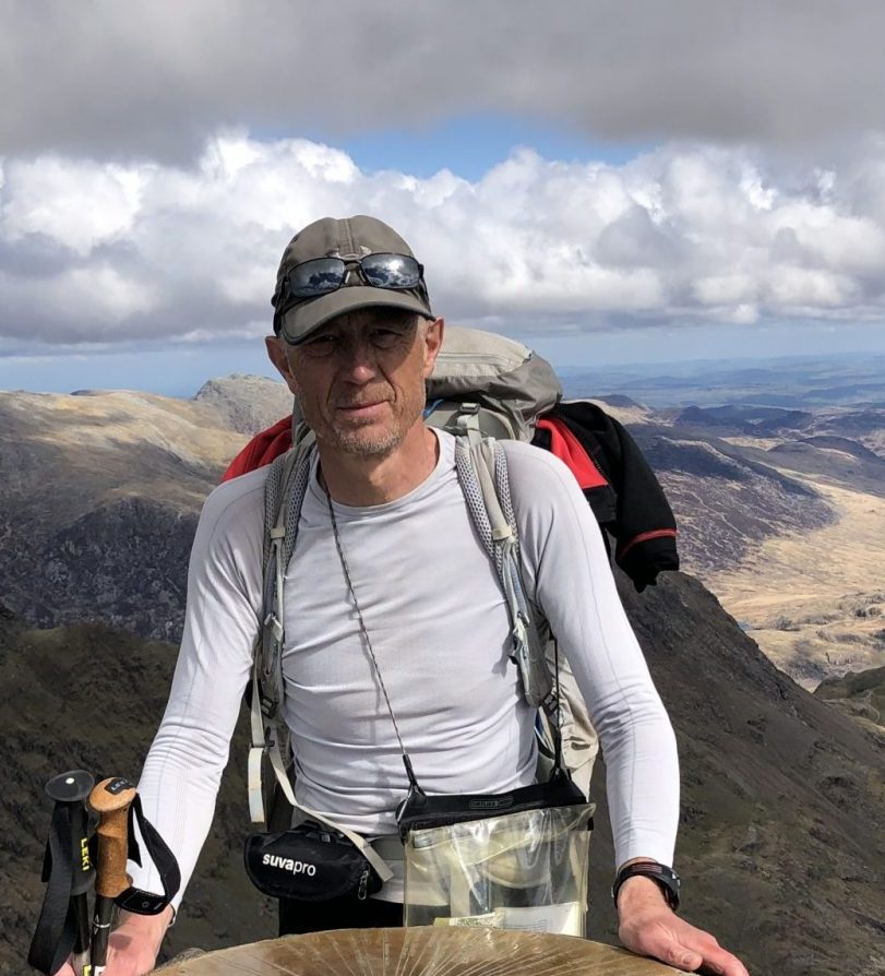
I arrived in Cardiff on Tuesday 15 March 2022. Whilst not an obsessive about ultra-light backpacking, I have done what I can to reduce the weight of my pack, which came in at a tad under 10kg (without food and water). The plan was to walk the route at a brisk if not exceptional pace, mostly wild-camp in remote spots, whilst possibly dropping into Youth Hostels if the weather turned or I otherwise needed a bit of mollycoddling. Because of the last-minute nature of my decision, what I didn’t have at this point was the Cicerone guide, but a quick diversion into Waterstone’s put that right; Cardiff Castle was a few metres up the road – I was at the start-point and good-to-go.
It is worth noting at this point that I’m a poor follower when it comes to hiking. For years, when out with the family or other groups, it is me that has the map (OS 1:25000, always!), plans the route, gets us lost, and eventually leads to the finish. So this was going to be a somewhat novel experience, with George and Richard (authors of the guide) providing direction, advice and commentary. I had stored the 1:25000 maps and GPX on my phone, but I was determined to keep this switched off and in my bag as much as possible.
I had anticipated the start would be a bit of a plod through the urban centre of Cardiff followed by the wasteland of peripheral industrial or retail parks. Happily, it was nothing like this: the path goes through the serpentine Bute Park, which itself follows the Taff river upstream. This takes me pretty much to the M4, which appears to be a clear demarkation between Cardiff and the countryside beyond. Also, I meet the first serious hill and second castle – the rather bonkers Castell Coch, which looks like it should be in southern Germany, rather than Wales, although George and Richard suggest a visit is worth the effort. And from here, I’m up onto high ridges with panoramic views over Cardiff, the Bristol channel and the towns and farmland of this part of southern Wales.
Here we go then. The guide says I’ve 480km to walk to get to Conwy. There are going to be sections well away from towns and shops, where I’ll need to carry several days of food. There’s an awful lot of ascending, and I’m going to find out that the route can’t seem to spot a trig-beacon without deciding to pay it a visit. I reach Machen, the end of stage 1, as the last kids are leaving school, and I pop into the sweet-shop myself to load a few more calories. I crack on, keen to make the most of the daylight left, and get myself high in the hills for my camp. And lumpy it certainly is, as I now haul myself up the 362m of Mynydd Machen, immediately drop 300m into Crosskeys, only to hit the sharp ascent to the 419m high Twmbarlwm. So no easy first few sections then? Not really, unless you compare with what’s to come …
By the time I’m overlooking Cwmbran and Pontypool, the light is fading and I’m tired and hungry. I’m not paying attention to George and Richard who acknowledge that the path is “indistinct” (for which read, “non-existent”), but provide detailed guidance (“follow the contour…”, “650m further walking….”, “swing to the N”). Oh dear! I overshoot and find myself several pylons further west than I should be. The area seems remote enough that I could camp here – except that I have no water, and this is a dry hill-top. With a feeling of defeat I get out my phone, locate myself precisely using the 1:25000 maps, identify the whereabouts of the nearest stream – which fortuitously is on the true route – and plot how to get there, which by some irony involves walking right past what must be the only trig-point near the Cambrian Way that is not scheduled to be visited. By now it’s seriously dusk, but I’m keen not to advertise myself with the head-torch, so I make my way slowly through the gloom, taking a longer dog-leg down the slope rather than risk a direct descent. The flowing water is brisk and clear, I’m well hidden from the lights of the town below, and I find a curl in the stream where I can pitch and flop. Tea. Night one. All good so far.
Day two, was supposed (by BBC Weather) to be the only one with rain in the next couple of weeks, but dawned fair enough. Now back on route, I soon come to woodland (“No Camping”) with awkwardly narrow kissing gates, for which G&R thoughtfully provide an alternative route, but I squeeze through. Then down to Pontypool and another well-apportioned park to take me through and out of the town, followed by a steep climb which gives way to a gentler climb over most of this stage to Blorenge, a 559m hill overlooking Abergavenny. By this time the drizzle has set in, and I reach the town a bit bedraggled and definitely hungry. I contrive to potter about until it passes 2pm, when the cakes in the bakery are all reduced to £1 each. I have three (why not?) and scoff them in the shelter of the market. And then onwards and very much upwards, to Sugar Loaf – the iconic isosceles hill to the north of Abergavenny which marks the start of the long horseshoe of the Black Mountains (there’s another set of Black Mountains to come – not much further on) that turns at Lord Hereford’s Knob and runs back southwards to Crickhowell. On top of Sugar Loaf I look east, wanting to pick out Cleeve Hill, Gloucestershire, which is home. But it’s too hazy and I have to settle for the nearer May Hill, the highest point in that county west of the Severn.
After Sugar Loaf, I drop into a green vale, before straight up onto the ridge. The weather has cleared and I’m able to eat into the miles towards Capel-y-ffin. But by a stroke of almost unsurpassable stupidity, I again find myself without water whilst looking for a place to pitch camp. Again, I resort to the 1:25000 maps on my phone, which show springs some 120m lower in height than my prospective site. I drop the bag, grab my phone and torch and hare down the hillside to get my bottles filled from decidedly sluggish flowing water. Then haul-ass back up, in time to put up the tent in the last rays of the sun. Brew well-earnt.
Day three, and the sun is shining. There’s a way to go northwards along the ridge, rising most of the way. Over the valley to my right runs Offa’s Dyke path, parallel to this one; the Cambrian Way seems to be squeaking the higher altitude as I proceed. I had been eyeing the 300m drop into Capel-y-ffin with some scepticism for a few miles. What was the point, when there was a nice straight path that proceeded along the ridge? I recalled that in some other century, I had stayed in a Youth Hostel in the village, so maybe this was a legacy to cater for that long-gone accommodation option. An angel and daemon took up the debate: whether to cheat and go straight, or to stick with the route and relinquish the hard-gained altitude. Reader, you will be pleased to hear that, as on every similar occasion on this journey, the angel won-out. I dropped like a stone into Capel-y-ffin (pausing to drink deep from the gurgling stream under the escarpment); and then … I rose like a stone (ie contesting gravity for every centimetre of regained altitude) up the other side. My exertions were aided greatly by the happy innuendo that I was, to all intents and purposes, mounting Lord Hereford’s Knob. I sniggered on. To be eventually bestowed more worthy reward, namely the wonderful views north over the rolling Welsh farmlands stretching far, far away. This is a magical vista, giving a sense of timeless human engagement with the countryside. Fields and woods and hills and streams. Hamlets and homesteads.
Right, enough of that. This is the point to turn back southwards towards Crickhowell. I was keen to get there this evening in order to resupply my food. The guide said there was a shop, but I wondered if it would still be open past 5pm. If not, I was going to have to delay there till it opened in the morning. Meanwhile the mists rolled in, unforecast. I togged up in my waterproofs, and walked on, soon to have the view reduced to the inside of a cloud. Frankly, over the years I’ve seen plenty enough of this, and in my dotage I’ll sooner stick to the valleys than endure this monotony. But I consoled myself with the forecast of weeks of sunshine to come, and with the recollection that, of all the Cambrian Way, this is the bit I already know best, so I could sort of piece together from memory what I was now missing.
With the guidebook at risk from the elements, I stuck to following a basic compass bearing (“south-ish”) and the strong footpath. Again, I should have been more attentive to G&R, as I missed a couple of forks in the path, ending up twice walking two sides of a triangle. And approaching Crickhowell, I concluded the more obvious route was via a rather nice looking wooded valley, when in fact G&R were more direct: over the top of Table Mountain and down. I quickly banked that the petrol station was open and looked like staying so for some time. But walking into the village centre I found the shop still serving, and stocked up on supplies there. I then found myself drawn, not south and out of the village, but the 10m or so north, to the chip-shop, whose fine aromas enchanted and enticed me in. As luck would have it, the kid serving was clearly on his first day, and interpreted a “large” portion as being all the chips he could fit on the paper, and still be able to fold it. Weighed down with my bounty, I found a bench and did what I could to refuel. But even after the hard-miles, the mist, the wind and rain, I could not finish the portion. Defeated and ashamed, I wearily plodded out of town, into the enveloping concealing darkness.
My earlier, rather ambitious, plan had been to haul out of Crickhowell up onto the old contouring tram-track at about 350m up the hill, and camp there. Weighed down by provisions and a belly full of potato, that was not now going to happen. A stealth camp would be required, and eventually I found a spot by a river (so water, then) in a flat grassy field, empty of crops or livestock. I determined to be away early, and practised a spiel to any curious farmer, along the lines of arriving after dusk and leaving before dawn; no nuisance, no trace. I put up the tent in near darkness, crawled in and passed out, enjoying the sleep of the well-fed exhausted innocent.
By now I had more or less adjusted to living by sun-time. I was tending to wake about 6am, around dawn, and getting away soon after 7:30am. I started looking out for a campsite about 6pm and seriously want to stop walking before 6:30pm. There was usable light till about 7:30pm, and I would usually be in bed and in happy contemplation sometime around 8:30pm. Even with all the exertion, I can’t sleep 10 hours a night. But I could enjoy a relaxed semi-consciousness leading into sleep whenever it came.
Day four, and I rise early. I notice that I am actually just about visible from a farm-house, and skip my customary coffee and have a rushed pot of muesli. I’m half-packed when I notice the obvious occupants of the property also out and about, walking the dogs. They spot me, but seem disinterested. I rush my final packing and take-off, needing to walk past the farm. But when I do so, I see it is actually a holiday cottage, clearly for short-let, and the dog-walkers are simply this week’s tenants, so understandably unconcerned by some scruffy old-soul temporarily resident in a nearby field.
Glycogen stores well and truly replenished I tackle the seriously steep incline formerly a tramway for long-closed mines. According to G&R I climb vertically 180m in the course of a horizontal distance of 500m. Blimey, that’s some. I’ve no notion of the folk who created these constructions, but I have to imagine their lives were tough and dangerous, full of muscle-busting work with poor nutrition and health-care. I’m reminded that any hardships I face on this walk are those I choose to take on. I also have the back-up of assured health-care, and the capacity to eat well and healthily whenever I want. I can also stop, pause, rest as I please. Now ascended, another tramway hewn from the rock contours the hillside for a kilometre. After the lung-busting, comes easy walking.
The guide splits the Cambrian Way into 21 stages of differing lengths, difficulty, and expected duration. What they all share is that they start and finish at a place with vehicular access, and usually this is a settlement of some sort. Thus far I’ve managed to complete five stages in three days, but that rate is going to be cut by today’s whopping 33.5km stage 6 to Storey Arms, which includes 1720m of ascent. With the knowledge of this ahead, I’m not too grudging of the 2.8km of road-walking (admittedly, uphill) that lie ahead. Bearable in the sunshine, but not a great deal of fun, given that the road, although notionally only a “minor” one, is actually wide, straight and busy.
Having got that out of the way, there follows a stretch of moorland that I am particularly keen to navigate well. G&R give clear guidance, (W for 300m, swinging SSW for 400m, bear right at the fork), but frankly I’m not all that confident I can follow this. How do you judge 400m over hilly, boggy, hazard strewn terrain? But with these instructions, compass and the broader guidance “head for the trig-point” I manage to get myself on a track I can identify once I reach it. Walking on, I get to the place I didn’t want to miss: the Chartist Cave. As I approach I sing aloud the bits of The Red Flag that I can remember, particularly the lines about it flying above our infant might, cheering these pioneer socialists. I think on about how socialist activism has long included demands for recreational access to the countryside, seeing this as a right all should share. My private enjoyment of walking has been enabled by campaigners who pressed and agitated on my behalf decades before I was born. Cheers Tony (and Tom and countless others). I spend the next hour contemplating how things would be now, if the 1945 Labour Government had had the gumption and energy to nationalise all land. Would our society be freer? More equal?
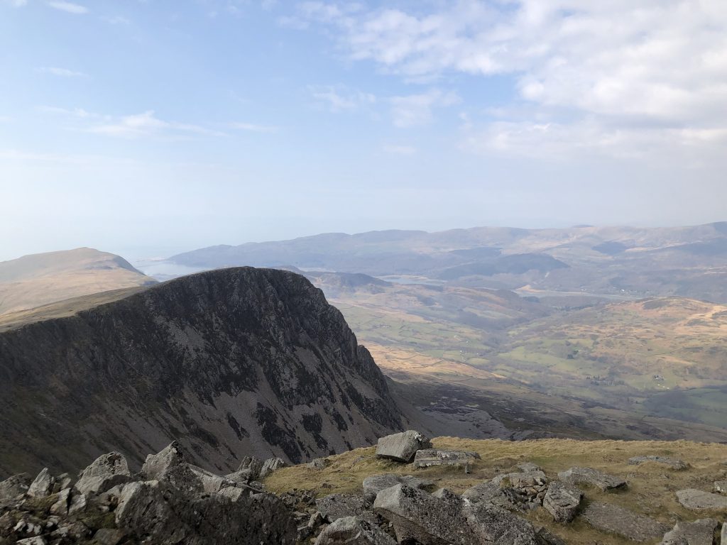
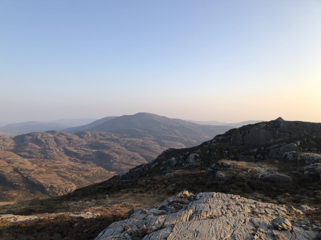
I plod over the moorland, losing the path, but with the bright sun to my left a handy guide to the correct direction (west-ish). I hit the right point in the access road, and confirm to a farmer that I’ve not seen any of his cows whilst crossing the moor. So onwards towards today’s highlight, which is the great ridge of peaks of the Brecons, which starts with Craig y Fan Ddu, and rises in successive waves to Pen y Fan and Corn Du. The peaks are all at the meeting points of a line of crescents, which means the splendour of the ridge is visible whilst one is up there on it. There are swooping drops on the northern side, as horizontal abruptly turns vertical. The mountains soar in the sunshine and the views north are breath-taking. I’ve not been here for over 10 years. Why on earth is that? Although optional, according to G&R, as far as I’m concerned a visit to the lesser peak of Fan y Big is obligatory. As I walk on, I contrive to achieve maximum smut regarding my achievements: On top of Lord Hereford’s Knob yesterday, up Fan y Big today. Oh how I chuckled.
After the symphony of peaks with its crescendo of Pen Y Fan and the final notes of Corn Du I head down towards the decidedly discordant A470 at the Storey Arms (no pub here that I can see). Being Friday I’m passed by successive weekend warriors going the other way, some laden with booze, obviously intent on a crisp night in the hills. My plan is to get as far up the other side of the pass to be out of sight and sound of the road. It’s a stiff climb, but thankfully not too far and I pitch on tussocky moorland on the flanks of Fan Fawr at 530m. At 3am I’m woken by easterly winds hammering the side of the tent. My little Terra Nova Superlite Voyager has a geodesic design, and so far has stood up to everything. But it works best with its arse to the storm, and I’d pitched it with only an eye to the slope of the hill, which meant it was catching the wind broadside. I weighed my options and, after maturely evaluating each, chose to pull the sleeping bag over my head and pretend the tempest wasn’t there. Right decision. The wind pounded on, but the Superlite was its equal, and I even managed a bit of intermittent sleep.
The easterlies kept up all the next day, several times knocking me off my feet. I presumed that this was the price to be paid for the otherwise perfect walking conditions of cool cloudless sunshine (and, let it be said, the wind was behind me, generally aiding my progress). The morning involved ascending the next great peak of the Brecon’s, Fan Gyhirych, which again has a majestic curving sweep with a north facing outlook. Getting there involved crossing more moorland, and again I found the overarching route suggestions easier to follow than the more detailed 400m this-away, 250m that (so that would be west-ish, then). With no real hazards other than more or less boggy terrain, this worked for me. G&R offer the route alternative of by-passing the stage-end at Glyntawe, if you have no wish to stay there overnight. Effectively they’ve drawn a straight line between Fan Gyhirych and the even taller Fan Brycheiniog (802m) and invite you to hold this as best you can. Superficially this looks like walking one side of an equilateral triangle, when the alternative is to walk two. But I’m unconvinced there’s much saving in time or effort, as I’m now involved in a much more rapid descent of Fan Gyhirych, an up-200m-down-200m of an intervening spur, and then an attack on what is the steepest approach to Fan Brycheiniog. After that I feel I’ve thoroughly earnt my luxuriating in the gorgeous prospect of the views to the north.
Now it’s a downhill northern walk out of the Brecon’s National Park towards Llandovery. Slowly the landscape changes to a rural pastoral one, and I’m passing small hamlets and villages and exchanging greetings with cows and sheep. Lambs are caught between their curiosity of their brave new world with this odd creature (me) that’s in it, and their instinctive urge to stay close by mum. The route loops back into more remote country, and I’m aware that I won’t make Llandovery tonight, and I have to be more circumspect in my choice of campsite, to whit: I need something big, sturdy and solid between me and that east wind. I’ve spotted some woods, which might provide a buffer, although I’m wary of the proverbial “widow-maker” of falling tree-limbs. In the end I find a perfect nook by a stream on a west facing slope that is suitably sheltered.
There’s no signal on my phone, but I’d anticipated this and sent an “All-well” WhatsApp to my wife a bit earlier. We have an arrangement that I send her my campsite grid reference every evening, but she shouldn’t be concerned if nothing arrives, because often I will drop into a valley (or cove etc) in the evening. I’m normally good at planning for this, and send a note whilst I still have a signal, but the deal is for her not to worry unless she hears nothing by noon the following day. Often I just have to clamber up a hillside a bit, or gain a line of sight to a likely antenna point. In fact, on this trip this was the only time I didn’t have a signal when I turned in.
Day six, stage eight to finish and nine to commence. In this tucked away spot I faff around a bit longer before getting away. I’m actually a good eight or nine kilometres from Llandovery, and become a tad frustrated at the time it takes me to get there. I receive a WhatsApp message from my brother in New Zealand, reminding me that today is equinox and asking that I hug a standing stone and if possible send him a photo. It’s a shame, because yesterday I breezed past the impressive Maen Llia and had appreciated its isolated majesty. As the route becomes more pastoral, so I need to follow G&R’s instructions with precision as road-walking alternates with well-marked paths through woods and fields. For the most part I do well, although I find the 1:50000 maps not very helpful for this kind of navigation, familiar as I am with the field-boundaries and other detail of the 1:25000 series.
The delay in reaching Llandovery is as well, because being Sunday the Co-Op only opens at 10am. Knowing my predilections, I’ve written a detailed shopping list of what’s needed (and, by extension, what’s not), but it’s no good: I still manage (as ever) to exit the store with far too much – food for five days, not three. I polish off the selection of fruit immediately, but my pack is still shockingly heavier. Why do I always do this? Kid-in-a-sweetshop mentality! The only consolation is that at least the increased load is helpful preparation for some other trips I have planned. Actually, over the hours that follow I accommodate myself to the new weight, and find other benefits, such as looking forward to tonight’s meal, which will include real vegetables.
The route out of Llandovery is along minor roads. It’s all quite pleasant, except that in the sunshine on the asphalt and with the ascent it’s hot, and I’m carrying not a drop of water. Seemingly another of my repeated failings is neglecting to look ahead for supplies. I experience how dehydration swiftly impacts physical performance and given the big miles I’m attempting this makes the situation even more stupid. The Cambrian Way is joined by some other (much better marked) long distance footpath and we coincidentally march up hill, me becoming reconciled to parched hardship for the next hour. We veer off onto a bridleway and I note water trickling down the ruts made by farm-vehicles. I can’t drink that, can I? But the water is flowing and is clear and cool, and I find a pool deep enough to submerge a bottle. I drink deep (via the Sawyer water filter) and like the flicking of a switch feel immediately restored and energised. I go over the crest of the hill and then drop into the beautiful Towy valley, which I follow upstream for the next few kilometres, alternating road and footpath. There are occasional homesteads, a pub, a campsite, but the valley feels sparsely populated and remote. Possibly in summer there’s a lot more activity. Eventually the path abandons the road, heading further along the river, which now has a steeper gradient. The countryside becomes more wild and remote, although I give up consulting the guide, since the direction of travel is clear. I meet one walker and then a couple: all of them have done the Cambrian Way themselves, and are admiring and encouraging of my efforts. The husband gives me some advice, for which I’m later grateful: “When you get to Cadir Idris, it looks impossible, but believe you can get up the hill, and you will.” I’m heading for YHA Ty’n-y-cornel, reputedly the most remote hostel in Wales, but it’s taking me sometime to get there. I make the classic navigational error of manipulating the vision I see into the features on the map where I want to be. But I can’t sustain the illusion, and without a 1:25000 I’m not able to use the close elements on the ground to pinpoint where I am. I resort to the maps on my phone and I discover I’m much less further forward than I’d hoped. I stumble on, well over 30km into my day, and still well short of the destination. The path twists and buckles along the stream. Woods come down the hillside and throw mud and roots in my way; the stream forks and forks again and I have to think to hold the right path. I slip and I’m pitched forward, with the heavy pack ensuring I go down. The good news is it’s a soft landing. The bad is that I flop into sticky wet mud. Somehow most of my torso is spared, but my trousers are flappy, wet and filthy with clingy mud.
I had by now sort of decided that I would wild-camp all the way, but in my low mood, weary and muddy I ideate on a bed in the hostel. I tell myself to get a grip, and that the original plan stands, but I know I’m going to equivocate all the way to the front door. Finally I reach a track so rocky that it’s difficult to conceive what is its purpose, but this soon develops into a farm road and the hostel hoves into view. It’s shut. Decision made for me; I slow down to admire the bench dedicated to Tony Drake, and then it’s onward into stage 10 and onto some unnamed moor to the east of Cwm Berwyn plantation. I target a spot close to a river and am in luck, the river is flowing and there is a dry track running over higher ground where I swiftly put up the tent. The only problem is that, as the sun sets, I become aware of some obviously raging moorland fire several kilometres to the north. This is a bit incongruous with my soaked shoes, currently chilling in the lobby of my tent. Moorland walking seems to involve each footfall plish-plashing ankle deep into standing water. But it has to be acknowledged that at this early point in the year, last year’s grasses are dry as tinder, and there is no new Spring growth. So I guess the fires are consuming the desiccated dead material that would normally be sodden with winter rainfall, and is due to be shed in the coming weeks as dormancy ends. The wind is still blowing briskly from the east, whereas I’m pretty well due south of the flames. I also see on the map that there is a road, albeit a minor one, between here and there. I determine to keep an eye on developments through the night, and do so: at every one of my regular awakenings I poke my head out to check. The fire stays where it is, and by the small hours it has disappeared.
Day seven I make may way across and down off the moor. There is a handy bright-red phone box to aim for, and I spot a car parked nearby with its driver leaning against the roof, clearly following my progress. When I eventually get there he introduces himself as local countryside warden. The evidence from the fire is close by: the blackened remains of gorse and heather. He tells me the fire brigade had been on site till the small hours, and I tell him about my watchful night. As I set off he gently reminds me that wild-camping is not allowed in Wales. He’s been so warm and pleasant that I spare him my diatribe on the idiocy of such proscriptions, and simply note I’d been at over 450m on open moorland.
Whilst I was volunteering at a Youth Hostel recently I met a bunch of National Trust wardens, who told me they had spent much of the summer of 2021 politely but firmly moving on wild-campers in the Lake District. But the thing was that these were folk who had turned up in a car at some lakeside spot, and supposed it OK to put up a tent and fire up a barbie. I figured the wardens wouldn’t even have seen me, far less had anything to object about, as I would have been high in the hills well beyond the reach of roads. So I sort of get why, in our crowded country, it isn’t straight-forward to set rules about wild-camping. The accepted protocols (arrive late, leave early, cause no nuisance, leave no trace) are easily breached by those not signed up to the spirit of the activity. Maybe the best is the kind of informal arrangements we have now, where a quick quiet camp is ignored and tolerated; which of course, works for me.
From the phone box (happily saved from removal, the warden tells me), the path heads back up to moorland, and I am successful this time in following G&R’s instructions, which take me off the moor at precisely the right point to enter forestry, and then navigate through the plantation to the abbey ruins at Strada Florida. The place is closed and deserted, and I don’t see a soul whilst I’m briefly stopped there for a rest. There is nothing more to delay me, so I head off for a few kilometres of pleasant road-walking, before turning up hill towards the lakes. I pass a sign marking the half-way point of the Cambrian Way: it’s taken me six-and-a-half days to get this far, and cements my resolve to get to the end – downhill all the way.
Stage 10 ends on a small track near these high lakes that feels, and is, in the middle of nowhere. I walk straight on, into stage 11, and soon reach Claerddu Bothy and stop to look inside. Essentially it is in good shape, and had my timings worked out differently, it would have been a great place to stop. Being a boring old fart, I despair that so many folk using the place seem to feel the need to write inanities on whatever surface they can find. There’s also plenty of rubbish and all-but-empty bottles, like fuel and oil. How difficult is it to leave the place better than you found it? I take the least empty gas cylinder (which later makes me two cups of tea, and which I carry until I can properly bin it). The walk continues as a plod over moorland, with the occasional tarn and hill-top to vary things a bit. In mist this would be grim, but in the fine sunshine and bright blue sky, everything is clear, and the obviously wetter bits can be skirted around. The way drops from the moors into a valley, but the far side is farming and then forestry. The change and easier navigation is welcome. Forests are easy places to get lost, but the route is well-marked, and the guide is helpful and exact, eventually bringing me to what is everywhere simply described as “The Arch”. This large brick structure stands somewhat forlornly and purposelessly by the side of the road: a monument to some past royal jubilee. This has been a long day, and I’m hoping to find a camping spot somewhere before Devil’s Bridge. There is some promising forestry along the track, but no where looks nice and secluded. Exiting the forest, I try an old trick of walking to the top of the small hill to my left. Hill tops are often: a) flat; b) well-drained; c) away from prying eyes. So this one proves, and on this occasion I’ve stocked up on water at a spring a few kilometres back. I’m looking down onto Devil’s Bridge and across the valley. The sun-sets, stars emerge, and I’m just about on top of the world.
Day eight, and I’m up bright and breezy and half-packed with the tent down when I hear the obvious sounds of a farmer puttering around checking on the lambs. He is with a woman I presume to be his daughter and they drive over. I’m expecting some frosty exchange, but they are actually both friendly and rather chuckled to have caught me. I explain my Cambrian Way journey and they are interested and appreciative. They turn to go, without a word of admonishment or annoyance, and I thank them for their reasonableness. I head off towards Devil’s Bridge. It’s actually a huge plunge into a steep wooded valley and up the other side, in the process crossing a narrow-gauge railway. I go through a pretty hamlet of Ystumtuen in the bright sunshine, with the blue blue sky starkly defining the line of the hills. Then it’s past various old mines and on to Ponterwyd, where there is a petrol station I could stock up at, except I’m already well-provisioned-and-then-some, so I settle for a few apples and crack on.
The guide notes that the route now goes up into wild and remote country, with navigational challenges, but in fact in the fine weather and with G&R identifying a series of features, I find it pretty easy. There are endless fences running with the path that provide a reassuring hand-rail, although the moors do feel a long way from anywhere and the views look out onto unending country of hills, valleys and moorland. I get to Pen Pumlumon Far and find a nice sheltered spot to eat my lunch. Unusually there is another party sharing the summit and we set off together. I’m gratified that I easily outpace them, marching along right on top of the rounded watershed. In short order I pass the sources of the Wye and the Severn. The latter is 100m from the path, and well marked. I visit the notional spot, which is a muddy pond, not obviously flowing anywhere. It seems appropriately primeval: murky and ancient. Of course, any river has thousands of sources, but I suppose this one is the furthest from the mouth. The Severn is a mighty river – in the British context. It is not quite the Danube, but interesting to note that several county towns – Shrewsbury, Worcester and Gloucester, are on it’s banks.
I reach the stage end at Dylife around 5pm. There’s a shut pub there, but not much else, and I walk straight through. There is some forestry about four or five kilometres into this stage, and I reckon that might provide a good spot to camp. The navigation out of Dylife is not easy, so I’m pleased with myself when after crossing a short stretch of moorland I reach a field boundary marked with the familiar Cambrian Way sign of a traditional Welsh woman’s hat. The route, a bridleway, heads up hill. At the top I miss the gate, so straddle the fence, and then head north west, as indicated by the map. Having successfully used the guide all day, I’m keen to stick with it to the end, but I’ve clearly lost the path and I am reliant on dead-reckoning (south-west-ish). It kind of seems right, but I’ve a sense something is not good. I see a small road on a hill top over to my left and suspect that this shouldn’t be in my vision. I commit another cardinal (or would that be ordinal?) navigational-blunder, which is to keep buggering on, rather than stop and sort. What is happening is I’m drifting too far westwards, which puts me on the wrong-side of a deep valley and stream running north that should be to my left, but are now on the right. I’m dog-tired and the light is fading. I resort to the GPS on my phone, and place myself exactly. Although steep, I reckon I can negotiate the slope down the hill, and I hit the forestry about a kilometre off course. Not too bad, and I find a splendid camping spot by a stream, which means restoration with tea, and I nurse my bruised navigational pride – at least I’m in one piece, and in the right general area.
Day nine, and the weather is holding brilliantly. In fact it’s getting better, with the wind dropping to a breeze, although still bringing cool dry air from the east. I’m up and away early, as I’m keen to make the shop at the end of the stage to stock up on provisions. I am on a bridleway that loops around to join the Cambrian Way in about two kilometres, but I decide to chance going over a fence, into the forest and making directly for the way. I’m in luck, the forest is easily penetrable and I’m on a track in no time and quickly find the CW – a saving of half-an-hour. After the forest, there’s moorland and then a drop into an attractive woodland, where the path largely contours before arriving at Commins Coch, where the railway passes through. There doesn’t seem to be much here, so on and up towards the huge turbines of the wind farm on Mynydd y Cemmaes. The guide suggests deviating away from the service road when alternatives present, but I doubt I’m the first who has stuck to the easy road walking along the ridge, counting off the turbines one by one. At the end of the ridge the path heads east downhill, and then loops back through a forest. The guide suggests sticking to the path, which I do, but afterwards I’m disappointed that I was so conforming – I’d have saved at least a kilometre by taking a steep descent to the west. But by now I’m confident I will make the shop at Mallwyd, and I’m further reassured when I read the guide to be told it’s a service station at the junction of two busy A-roads – so likely to be working late. In the bright sun I walk over one more hill, then down past old homesteads onto a long access road that runs parallel to the A458. I stock up at the service station and rest at a nearby closed pub, where I munch away at the fruit I’ve bought. I decide that actually I really should bosh a large fruitcake I initially eschewed, and return to the shop to remedy that. With both bag and belly filled I haul up and out northwards along a road and then paths that take me by the river Dovey.
Even with me having walked a few kilometres of this stage 13 last night, I’ve so far today walked over 30km more, and the stage is still not done. The route takes me steeply up a quarryside, and I start wondering whether the designers (Tony Drake et al) had any thought for acknowledging the natural breaks at the end of the day. As it is, I’m not really bothered. I’m finding I’ve still got a good deal of stamina (probably due to the fruitcake), but more significantly I’m not planning to drop down into Dines Mawddwy, but rather (as the guide permits) skip this and launch straight into stage 14. I think if I was staying in Dines Mawddwy, I’d be a little disgruntled at having been obliged to undertake a pretty tough little climb at the end of the day, after walking 35km, only to descend again, to the village in the valley for the night, and then the following morning retrace that final down-hill back up to the quarry.
Me, I carry on westwards and up the steep slope towards the peak of Foel Dinas. I don’t interpret the map correctly, and I’m on the lookout for route round the top of a U-shaped valley. In fact, what I find is the path crossing a ridge with U-shaped valleys dropping away to both left and right. One side pine forest, the other homesteads and fields. It’s spectacular, not least because the drops are so steep that the farms below are both near, but utterly out of reach. I descend into a saddle, but there’s no water and I figure I may as well have one last heave so that this stage’s ascending is mostly behind me. So up the other side until it starts flattening off, and I can find a spot for the tent. Using the 1:25000 map on the phone I identify a stream nearby, and I’m able to replenish water supplies, and sleep the sleep of a man who has walked nigh on 40km over hills.
Day ten and the plan is to complete this stage, 14, and ideally 15 also. But there is the small matter of Cadair Idris to negotiate. After yesterday evening’s hard climbing, I’m rewarded by a lengthy walk along the top of the escarpment looking north and east. It’s clear and although my feet plod along, I feel like a soaring eagle lording it over the lands below. It’s relatively easy – though thrilling – walking, and I make it without issue to the trig point on Waun-oer, and then an easily navigated slow downhill alongside forestry. I spot cars parked on the road below, and turn north to head more directly down the hill to meet them. The paths are unclear, but I eventually make it and congratulate myself on the swift completion of stage 14 and head up (what I believe are) the flanks of Cadair Idris. It’s a steep climb, and I’m rather perturbed when it turns out to have a huge drop ahead. In fact what I’ve done is mistaken a small forestry road for the A487, and to compound my mistake, instead of bearing north to minimise the challenge of the ridge I’m now on, I’ve actually selected its steepest and highest point. I now need to walk north east along the ridge until I can find a path that will take me to the busy road, and so truly complete the stage.
Somewhat disarmingly there are loads of people, settled with picnics and hot-drinks, lining the paths on both sides of the A487. Many are clutching fancy cameras, and I discover they are hopeful of RAF fighters flying through the valley below. It seems they are there in hope, rather than cognisant of any schedule. I dismiss the gentler option offered by G&R, and labour past the static aerophiles up the steep hillside. The route is tough, and I trust that the fact it is well worn is indicative that it will get me up. My aim on any hill is to reach the top in one heave, no stops, continuous movement. This means choosing the right gear, which for me is the fastest I can go without lactic acid burning in leg muscles. So dead slow. I shuffle on, giving my quads and hams some assistance via heaves on the invaluable trekking poles. Eventually I can see over the other side, and I turn to follow the ridge, still upwards, but with a much easier gradient. It’s a long old pull along the ridge and several kilometres before the first proper peak is reached, Mynydd Moel. It’s not quite the highest, and is commonly neglected by those wanting to knock off Cadair. But I have been here before, most recently only a few months ago: last summer. Then we were on our way down, and completed our descent by following a steep wall south east – a pretty direct route back to the car-park. Now, still on my way up, I recall that it is further than it looks to get to the summit at Penygadair. I plod on, drawn to the peak. As I approach I can pick out the small number of fellow walkers who’ve already made it: most are taking it easy, highlighting the balmy conditions, once you find shelter from the chill on the breeze. The views north change and open, following the river Mawddach, far below. Barmouth and its distinctive railway bridge come into view – this area has it all: fine beaches, mountains, and river estuaries straight out of an eighteenth century Romantic painting. At the summit I WhatsApp a picture to the family, and then find a sunny spot to eat my peanut butter sandwiches.
Although it has been a tough slog to get here, I’ve actually still got 15km of this stage to go – a long downhill to Barmouth. The first five or so kilometres are along the ridge westwards, gradually swinging towards the south and losing height all the way. The views remain breathtaking, and Barmouth becomes a bit clearer. Then I plunge down the slope and into the pretty countryside with sheep, lambs and charming farmhouses. The path is directed along old bridleways, across a clapper bridge, and then down the National Trust owned waterfalls at Arthog. I’m parched by the time I reach the stream, and despite this being relatively lowland, I don’t hesitate to fill my bottle and (via my filter) drink deeply. It does rather seem to be taking a good long time to get to Barmouth. I’m knackered, and the route is contriving to meander down to the mile-wide estuary and then back and forth from the shoreline. I stick with it. I’m not really tempted to deviate, and right here, the only option is a busy road. Furthermore, I always find the views along the river Mawddach deeply moving, it just seems so mysteriously perfect. The tide is out, so I can cut straight to the bridge along a bit of shore. I join the hand-holding lovers and day-trippers plonking over the wooden structure, recently refurbished – which is great – who’d not want this bridge to last forever?
And so, Barmouth. I’m efficient and make my way directly to the Co-op, where I shop with wise parsimony this time. I do stock up on a good amount of fruit and veg, which I start eating as soon as I am out of the door. I call my son, poncing on a bit of free internet, but I have to be brief, as the dusk is bruising the seascape, and I want to get decently into the hills before stopping. I have reminded myself that on previous trips (notably SW coastal footpath) I wild-camped consistently, but much nearer habitation. The fact is that if you are out-of-sight at dusk you’ll be unlucky to be disturbed during the night. The steep path takes me out of the town, but once I have passed the last house I’m immediately looking for a campsite. I find one shortly, with a spring nearby and the tent is up in seconds, and I’m gorging on a mango, which is rewardingly incongruous for backpacking, and tastes all the sweeter for that. I am smack on the path, but I figure no dog-walker will be here before dawn, by which time I’ll be gone.
Day 11 promises to be the toughest so far. The guide labours the point that stages 16 and 17 are the hardest in terms of terrain, and urges walkers to use an easier alternative in bad weather. I have just about everything going for me. I’ve proved my fitness and stamina thus far, being able to turn in long days and big miles. The sun continues to shine over the cool clear air, and the wind has dropped to a breeze. The walk is essentially all uphill to the first peak, and navigation is not too challenging, since it involves holding the ridge line, with views to both east and west. My only concern, which has been growing ever since I started in Cardiff is my shoes. I have been walking in trail-running trainers, which actually have been great so far. They are lightweight with only limited cushioning and a tough but thin sole. Although I can feel the rocks and stones underfoot, this has not been too bad, and I know there is a school-of-thought that says this is the way to go. The problem is the upper, which started off shabby and with holes, and has only gotten worse as I’ve progressed. Both shoes have holes at the big and small toe, and I’m fearful these might join in the middle. The attempted repairs (with carpet twine) have been worse than useless. It has to be said, that the decline has been slow, and I’m sort of tempted to see if I can make it to Conwy on these. I’ve long since rejected the custom of wearing heavy hiking boots. Outside of winter, the high ankles don’t seem much use, the weight is unnecessary and unarguably they give you blisters. What I’ve also found is that any notionally “waterproof” footwear is only effective when new, and obviously no barrier at all to water slopping over the top. But once inside the water can only escape really slowly (due to the barrier) so your feet end up being broiled through the day. My trainers allow water to flow in easily, but it can escape just as quickly, and with good (Darn Tough) socks my feet have survived well and I’ve not had a single blister.
The route is clear, and the way up the first mountain, Rhinog Fach, follows a wall. I wonder why anyone bothered to construct such a serious wall up here. I suspect, like some ancient chieftain, it was to assert land-ownership. No doubt the workers were paid a pittance, and for someone owning huge tracts of Wales it was worth it to get a wall erected to demark the extent of one’s domain. Anyway, it proves a useful hand-rail now. My speed over the ground plummets. Every footfall needs to be calculated and planned, and it’s a hard haul uphill. This challenge only increases after I’ve reached the top and start to descend. It’s treacherous and needs care and concentration. The walking poles are invaluable, and I bend one when I wobble, and jam it into the ground to steady myself. It holds though and I make it to the narrow saddle before the ascent of Rhinog Fawr, which if anything is tougher still. Again the descent is more challenging than the ascent and I can’t seem to stick to a clear path, so regularly end up hacking over rocks and through brush. I reach the relative sanctuary of Llyn Du, and stop to dunk my sleeping mat in the lake in the hope of finding where it is punctured. It takes me several passes over both sides to identify the spot, but I’m elated when I eventually do so: I’ve spent a couple of nights having to add air several times after waking with my hip bone pressed into the floor.
The guidebook helpfully takes me round the mountainside and the path gets less demanding as I proceed. I enter a pretty wooded section at the end of the drop and then there’s a proper campsite at the stage-end, but I determine to crack on and see if I can knock off the big ascent of the next stage, 17.
It’s hard-work, and it takes a long time to reach each of the waymarks. I’m tired, and resort to the GPS to ensure I stick to the path. I decide to fill up the water bottles at a stream, to avoid any issues later on. Good planning, but adds two kilos to my weight. But, having completed the big climb, I’m able to drop the bag in a saddle, as it’s a there-and-back to the summit of Clip. Without the weight it’s like I’m flying, and I have to caution myself to watch my footfalls and take care. Nevertheless, it is an easy ascent, with a bit of clambering to get to the actual summit point. I surprise myself at how quick is the return to the saddle, and I’m able to make camp on some dry tussocky spot. I’m well over 550m up. The mountains deign to treat me to a fine sunset.
Day 12, I’m launched into stage 17, for which G&R allocate an extra hour for slow-going. I’ve learnt to trust their time estimates. On days with long not-too-demanding walking I can hit or even creep under their fastest time. But where it’s more technical, my old bones can be slowed by the hard descending, so I end up nearer their mid-point estimate. Yesterday I had a chat with some other walkers, who were suitably impressed that I’d started in Cardiff, but gently mocked the state of my shoes. This had brought home that I needed to replace them, so I get going soon after 5am, such that I can be on the move once the light is good enough. Although these craggy peaks could be by-passed, I visit every one, which in some cases involves a bit of a clamber up the final crag. The guide warns that although the ascent of Diffwys is straight-forward enough, the descent needs care finding the right route. I’ve drifted too far north and need to correct by reorientating myself. I resort to the GPS to rediscover the path, and get down safely. The mountains give way to farm land, and then to the small roads and tracks around the big reservoir, Trawsfynydd. Although the tough part of this stage is behind me, I realise that I’ve got a good two hours of walking to Maentwrog – the stage end. I march on, at speed, now benefiting from the easy ground beneath. It’s all very pretty pastoral countryside, and I enjoy the contrast with the rugged mountains I’ve just left. I get to the main road, A487, before 11am. Good going.
Amazingly, lying in bed last night, high in the mountains and totally inaccessible, I have the world literally at my fingertips. With my phone I checked out the options and I’ve hit on the Millets store in Porthmadog. The big problem with me and shoes is that I need a size 13 for hiking and running, and no shop stocks a big range of these, and most have none at all. So it’s a bit of a gamble.
The plan is to hitch into Porthmadog, buy shoes and lunch, hitch back, resume walk. In my dreams I hope this will take about two hours, but the lore and luck of hitching are such that I could lose half-a-day on this. I offer silent prayers to the gods of hitch-hiking, and throw up a thumb. About four decades ago I was a determined and regular hitch-hiker, partly due to having no money but mainly because subscribed to its karma. These days I only hitch out of necessity in situations like this, where I’m hiking, but need a ride from somewhere remote into a nearby town. After about 15 minutes a van pulls in, and I’m soon chatting away to a local who has a wood delivery business. Formerly a keen hiker, he tells me about various local challenges, like the 3000ft x 14 in 24 hours. He drops me at the door of Millets. I cut to the chase and ask if they have any size 13s in the shop. They have a single pair. Although expensive, they’re perfect. Without much ado, I wear them out of the shop. I undo the laces on my old trainers, keep these and chuck the ragged shoes into the bin. Then a quick detour into Lidl for a very hearty (and mostly healthy) lunch and a kilometre walk out to the road. A 15 minute wait is rewarded by another delivery driver, also a keen former walker. He decides he has the time to slightly vary his route, and drops me at the exact spot I started from. It’s 1pm. The trip has amazingly taken me exactly two hours. I couldn’t have done better. Votive thanks are offered to the gods.
Within minutes of resuming the walk I’m cursing my own stupidity at it having taken me so long to sort this out. The new shoes are perfect, and I’m aware that I’ve stopped compensating for the holes and rips that I had in the old ones. In these last days I’ve walked through some of the loneliest and most challenging mountains in the country. I saw virtually nobody. What an idiot for doing this with shockingly shonky kit. I feel I should apologise to someone.
The path now goes through the wooded valley of Ffestiniog and tracks the narrow-gauge railway. When the line dives into a tunnel, the path more-or-less follows the same direction, but over the moor, reaching a reservoir. I miss the turning of the path up hill (the guide helpfully advises: “easily missed” – cheers) and its a 250m height gain, straight up to Llyn Stwlan reservoir. The path then gets steeper still, for the climb to Moelwyn Mawr which has a panorama of mountains far and near in every direction. The route proceeds eventually to find the expansive ruins of an old slate quarry. I’ve been here before, and recall it as a place to get disorientated and lost. The guide is helpful, and I take regular bearings despite the old buildings and streets. I can see the next target – Cnicht – it’s unmissable, looming over the whole area. But to get onto the ridge running south-west that will take me there, I have to head north, to avoid the impossibly steep slopes on the flanks. After weaving through a series of tarns I get there, and the more steady and straight-forward part of the ascent begins. By now it’s late, and I weigh up my options. I could camp here, or I could press on and hope to be up and down before nightfall. I’m not keen on camping on the top, but in an emergency, that is do-able. I decide to go for it. As I approach the summit I meet a couple and then two single walkers, all planning to spend the night near the top. As far as I can see, none of them has a tent as good as mine, so I figure I’m OK come what may. But it actually takes me much less time to crest the hill than I had anticipated, so now I have a good 90 minutes to descend, which is comforting, as initially it’s precipitous, challenging going. Cnicht is a fantastic knife-edge arret, a cut-jewel of a hill, with plummeting views to left and right. I make a note to climb it again when I’m less hurried. Being so steep, of course, the loss in altitude is swift, and soon I am returned to sheep country. I press on, because I’m hoping tomorrow to complete two further stages. But the light is shattering into a palette of reds, oranges and yellows, and fading too: I need to call it a day. I faff around, but eventually find a flat enough campsite, and in short order get up the tent, and brew tea.
Day 13. I have hit on the idea of being home on Monday evening. Today is Sunday. It is unfortunate that once I start planning for the end of a walk, there’s a little part of me that wants it to be over. And often that wish grows and grows. So although I’ve still been underway for less than two weeks, I’m now thinking of home and all the comforts and conveniences that I’ll have to enjoy. I also know the times of trains, and clocked there is one at 16:30 and then a final one much later. So getting the 16:30 is a good objective, but one with a safety net. I have two hard days ahead. The plan today is to complete stage 18 by walking into Beddgelert, then straight into stage 19, over Snowdon, and then ideally completing stage 20, which is over the Glyder for which the book allocates an additional hour (over and above Naismith) because of the difficulty.
I’m up before dawn, and soon packed and away. The walk into Beddgelert is straight-forward, but charming along a swiftly flowing river through pretty woods. I arrive there about 08:30 and with super-self-control purchase just enough food to get me to Conwy. From here its a good 6km to the start of the ascent, and it’s easy walking along well made lakeside tracks. I’ve walked the Watkin path on Snowdon twice before. The first time was downhill, and it seemed a breeze. So I was rather ambushed the second time, when I went uphill from the Youth Hostel in pretty poor weather. It was brutal. So I’m pleased that G&R suggest deviating from this standard route to take a longer but possibly less steep alternative. This also means that from walking with lots of folk, I soon find myself alone again along this less popular footpath. It’s marked by a succession of huge sacks filled with stones, obviously delivered by helicopter and intended to shore up the path. I’m not sure it needs it, but I suppose that developing a better path here, will take pressure off the Watkin. About half-a-million people attempt Snowdon each year, and there are four main routes. So I guess adding another makes sense.
The summit is a hubbub of Sunday walkers, but great to see a properly diverse slice of Britain up there. I have to queue, though not for long, to get my photo at the trig-point. It is not quite 1pm, but I determine to descend a bit and get away from the crowds before lunch. I set off downhill, and shortly pick up the PyG track, which is steep at first, but evens out as I go. It takes longer than I suppose and it’s after 2pm when the Youth Hostel comes into sight. I find a sheltered spot and enjoy a proper break, eating stale bread and peanut butter bought in Beddgelert.
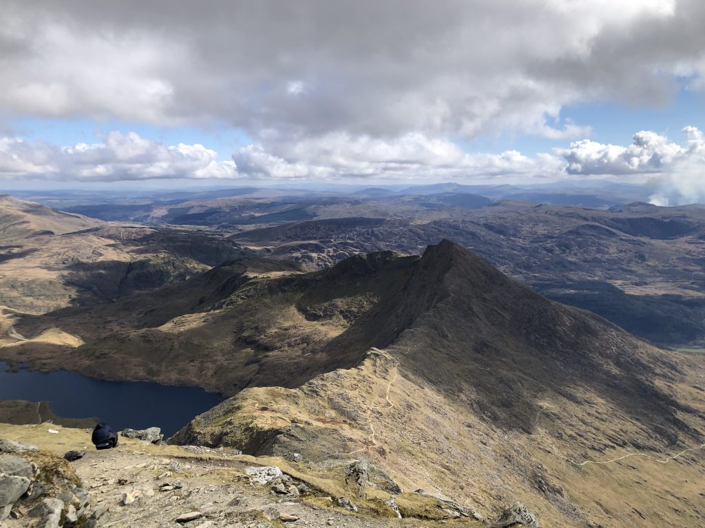
I walk the final kilometre or so to the end of the stage and without pause start on the next. This commences with 600m up, which includes some scrambling and finding one’s way through rocky outcrops. I note that there are very aged red paint flashes on the rocks, which I follow and find they provide a good path. This is like walking in Switzerland, and I appreciate the guide and wonder why no one has refreshed the markings recently. It’s still a hard slog, but at least I’m reassured that it’s going to be passible. The summit comes into view rather suddenly. A final haul and I’m in this moonscape of jagged rocks, and a castellated summit point. I try to follow G&R’s instructions round this, but eventually give up, and head directly for what looks like the highest point. This involves clambering over massive rocks, which would require care normally, but with my backpack affecting my balance, I need to be super-cautious. A fall here and I’d be done for: there’s no one at all around. I reach to within about 10m of the top, but decide I don’t want to take any more risks, and head down and off this outcrop. Thankfully the path to the next peak (Glyder Fach) is marked with cairns, so although the going is slow over the rocks I’m guided to the easiest route.
The descent that follows is the toughest I’ve done on the whole trip. It’s incredibly steep, badly eroded and really just loose rocks and grit. The trekking poles are invaluable, and I maintain a constant mantra of taking time and taking care. Check every footfall, ensure your weight will make you fall back rather than forward. I reach the saddle with Tryfan. The guide suggests this as a possible (though not obligatory) addition. Er, I don’t think so. The path now gets easier, and in places has been paved. It follows a stream downhill and I spot a couple of fell-runners coming from another direction. I’m going to make it to the end before darkness, although I then complicate matters by somehow losing the path, and finding myself in the bed of the stream, scrambling up and down boulders. But eventually I’m out of here, and the final stretch of moorland to Ogwan is easy. I’ve determined to brazen it tonight. It looks to me that there is a path but no track along the far lake shore. This means that if I time my pitching of camp to the moments just before dark, I’m not likely to be bothered, despite being in sight of the A5. The notion works, and in fact I find a little hollow that more-or-less conceals me, so I’m cosy and secure for the night.
Day 14, and the plan is to wake well before dawn, and get away as soon as the light is good enough. I’m pretty sure I’m going to be fine, but the clocks went forward over the weekend, which means I’ve been robbed of an hour, as dawn is now an hour later, and consequently 16:30 rolls around sooner. I skip coffee, and I’m soon plodding along the lake, at the end of which I take a sharp left and attack the gradient head-on. Boom! It’s another uninterrupted ascent of 600m. I’ve decided to consult the GPS on my phone for today. I know I’ve got enough battery (and then some) to see me through, and I don’t want any slips on navigation that will add to the time. Nevertheless, it is still easier to follow the path on the ground, which is clear enough when I reach the rocky bits before gaining the first summit of the day, Pen yr Ole Wen. I’m a bit annoyed that mists swirl around the tops. Clearly these will be burnt off in the next hour or two, but any occlusion of the view is not welcome, although I know I’ve been spoilt these past two weeks. There are six 3000 foot peaks today, although thankfully the drops between them are kept to 100m or so. It’s a kind of ridge walk for the first part, and after the slow ascent I’m able to power on at speed.
I’m 13km into the day, and having knocked off the last 900m+ peak, I take a break for bread and peanut butter. It is a net descent of 900m into Conwy, but there is still plenty of climbing left to do. In particular there is a steep drop into a valley with pylons and electricity cables (and no water!) then another straight-up ascent of 200m, effectively using a wall as a hand-rail the whole way. The weather remains fantastic, clear and sunny and warm. In the valley I strip down to base-layers, set myself into “up-hill-gear” (slow, steady) and off. The wall changes direction twice on the way, so I use these as goals and milestones, breaking the long-haul into three parts. A few horses observe my progress through the gorse and heather. As I reach the summit Conwy Castle comes into view, and I’m reassured that I will make the 16:30 train. The path, though, rather than heading direct for the town, bears off to its west in order to get in one final hill, hard by the coast. Although not tempted to cheat now, I wonder whether this was necessary, given all the miles already done, both today and in the days prior. However, as the sea comes into view I accept it was worthwhile with fine views out over the waves. I’m drained by now, so when a dog comes at me barking, I fly into a rage and volley a stream of obscene invective. The owners are a bit shocked, “He only wants to play,” but I’m not remorseful at all: do I look in any way like a bloke out looking for a dog to play with? And after one final peak, it’s downhill into Conwy. I check the train times. Had I really made the effort I might have made an even earlier one, but I’m glad I didn’t. Arriving at 15:35 gives me time to get some fruit and chocolate in the store, snap a selfie by the castle and phone home. I made it.
Summary of my itinerary – camping spots
| Day | Date | Stages | Grid Ref | Location |
| 1 | 15/03/2022 | 1,2 | ST 26344 97284 | Just above (south of) Pontypool. |
| 2 | 16/03/2022 | 2,3,4 | SO 28315 24020 | On the ridge of Black Mts before Capel-y-ffin |
| 3 | 17/03/2022 | 4,5,6 | SO 20200 16608 | Just past Crickhowell (farm field!) |
| 4 | 18/03/2022 | 6,7 | SN 97260 19999 (530) | Flank of Fan Fawr, just west of Storey Arms |
| 5 | 19/03/2022 | 7,8 | SN 78745 28443 | 10k south of Llandovery still in wild country |
| 6 | 20/03/2022 | 8,9,10 | SN 74542 55548 (450) | Open moor above YHA Ty’n-y-Cornel |
| 7 | 21/03/2022 | 10,11 | SN 74867 76002 | Hill top to south of Devil’s Bridge |
| 8 | 22/03/2022 | 11,12,13 | SN 84454 96967 | Remote valley Nant y Fedw (500m off route) |
| 9 | 23/03/2022 | 13,14 | SH 82965 13581 (515) | Craig Maesglase |
| 10 | 24/03/2022 | 14,15,16 | SH 61860 16090 | Just past (north of) Barmouth (stealthy!) |
| 11 | 25/03/2022 | 16,17 | SH 65539 33014 (565) | Saddle north of Clip (Rhinogs) |
| 12 | 26/03/2022 | 17,*,18 | SH 62438 45182 | Off Cnicht about 2km before Nantmor |
| 13 | 27/03/2022 | 18,19,20,21 | SH 65231 60492 | Shore of Llyn Ogwen, plain sight from A5 |
| 14 | 28/03/2022 | 21 | Conwy 15:30 |
* 2 hours off trail hitching into and out of Porthmadog for shoes
Some concluding thoughts
The Cambrian Way really is a fantastic walk, which stands comparison with any other in the UK. It’s proper tough in terms of the ground underfoot and the extensive ascending. I walked it in more-or-less perfect conditions, but in bad weather it would require considerable caution and good navigation skills.
I would definitely recommend wild-camping if possible and practical. There was limited alternative accommodation en route, and there definitely aren’t sufficient bothies or hostels for the budget traveller. Wild camping is not strictly permitted in England and Wales, but the general rules are:
- Be on foot/bike in a small party with only one tent.
- Arrive late, leave early.
- Cause no nuisance, leave no trace.
- Definitely no fires.
- Any toilet should be well away from water-courses, and you should dig a hole 15cm deep.
Being a long way from people and habitation helps.
These days, under-taking this sort of expedition without a GPX is foolhardy. This can be obtained from the Cambrian Way official website or from Cicerone. As noted in the introduction, whilst not absolutely essential, the Cicerone guide is a useful and informative companion. A compass and ability to use it is essential, as there will be times when the best you can do is follow a bearing over a featureless moor.
Cambrian Way website: https://www.cambrianway.org.uk/ (opens in new tab).
Cicerone: Cicerone.